Revolutionizing
Image Analysis
for a Safer and Greener Planet
Enable cost-effective and continuous monitoring
for environmental protection and investigative accuracy.
ABOUT LTU
Texte à venir pour expliquer l’intégrité de LTU et la solidité de la société.
At LTU, we transform diverse images into actionable data through our innovative hybrid AI approach, supporting crucial environmental monitoring and investigative efforts.
TECHNOLOGY
Leveraging our computer vision technology, LTU promotes data democratization through AI in earth observation for sustainability.
Hybrid AI Approach
Our hybrid AI approach merges deterministic algorithms with advanced deep learning techniques, ensuring high performance and reliability across diverse applications. This method allows us to enhance the precision of our analyses while maintaining the flexibility to adapt to different contexts.
Proprietary Algorithms
LTU’s proprietary algorithms are designed to automatically detect changes in large volumes of satellite and aerial imagery, without requiring labeled data. This unsupervised method is not only cost-effective but also efficient in terms of power consumption.
Explainable AI
We prioritize providing explainable and actionable insights. Our solutions are designed to support analysts by offering clear and understandable information, facilitating better decision-making.
Sensors Agnostic
LTU’s algorithm supports various kinds of image sensors, including optical, radar, and hyperspectral imaging systems. LTU’s commitment to a multisensor framework ensures that its clients receive robust and actionable intelligence tailored to their specific needs.
LTU’s technology excels in detecting and monitoring environmental changes through any kind of imagery. By detecting threat changes, LTU enables continuous and cost-effective observations to drive decision processes.
Water Leaks Detection
By harnessing high-resolution satellite data, LTU identifies subtle changes in terrain and vegetation indicating potential leaks, ensuring timely intervention and reducing water loss.
Change Detection
Utilizing satellite imagery and its analytical algorithms, LTU enables users to track major environmental shifts from urban development to natural disasters with unparalleled accuracy to help make informed decisions.
Object Identification via Satellite
Leveraging LTU’s patented algorithms to efficiently identify and compare specific features in satellite images for risk assessment and monitoring.Industrial Maintenance
Leveraging advanced its algorithms and robust data analytics, LTU monitors quality throughout the production lifecycle. LTU can streamline the quality control process, enabling manufacturers to identify issues early and enhance reliability.
Edge Computing
LTU’s proprietary algorithm can extract significant features of any image to generate its unique « signature » to identify shared characteristics contained in large image reference datasets in quasi-real time.MORE LTU INFORMATIONS
At LTU, we transform diverse images into actionable data through our innovative hybrid AI approach, supporting crucial environmental monitoring and investigative efforts.
Paris
Toulouse
At LTU, we transform diverse images into actionable data through our innovative hybrid AI approach, supporting crucial environmental monitoring and investigative efforts.
RESOURCES
Innovation
Constantly pushing the boundaries of what’s possible with AI and computer vision.
Integrity
Maintaining the highest ethical standards in all our endeavors.
Sustainability
Committed to creating frugal solutions that support environmental protection.
MEDIAS
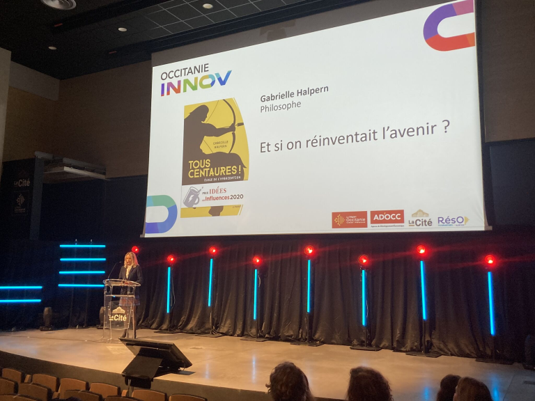
8 octobre 2024 : Occitanie Innov, le rendez-vous de l’innovation organisé par l’AD'OCC à La Cité Très belle conférence [...]
Explore articles and media coverage featuring LTU. See how our innovative solutions are making headlines worldwide.
CONTACT
Have questions or need support?
Fill out our contact form, and our team will get back to you shortly.

